


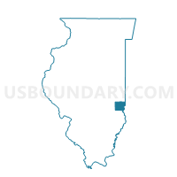
ANDERSON Voting District, Clark County, Illinois
About
Outline

Summary
| Unique Area Identifier | 564867 |
| Name | ANDERSON Voting District |
| County | Clark County |
| State | Illinois |
| Area (square miles) | 32.70 |
| Land Area (square miles) | 32.31 |
| Water Area (square miles) | 0.39 |
| % of Land Area | 98.79 |
| % of Water Area | 1.21 |
| Latitude of the Internal Point | 39.30382800 |
| Longtitude of the Internal Point | -87.72729160 |
Maps


Graphs
Select a template below for downloading or customizing gragh for ANDERSON Voting District, Clark County, Illinois


Neighbors
Neighoring Voting District (by Name) Neighboring Voting District on the Map
- AUBURN Voting District, Clark County, IL
- DARWIN Voting District, Clark County, IL
- MARSHALL 3 Voting District, Clark County, IL
- MARSHALL 4 Voting District, Clark County, IL
- MARTINSVILLE 2 Voting District, Clark County, IL
- MELROSE Voting District, Clark County, IL
- ORANGE Voting District, Clark County, IL
- WABASH 2 Voting District, Clark County, IL
- YORK Voting District, Clark County, IL
Top 10 Neighboring County Subdivision (by Population) Neighboring County Subdivision on the Map
- Marshall township, Clark County, IL (4,574)
- Wabash township, Clark County, IL (2,257)
- Martinsville township, Clark County, IL (1,602)
- York township, Clark County, IL (551)
- Anderson township, Clark County, IL (417)
- Melrose township, Clark County, IL (352)
- Darwin township, Clark County, IL (342)
- Auburn township, Clark County, IL (242)
- Orange township, Clark County, IL (230)
Top 10 Neighboring Unified School District (by Population) Neighboring Unified School District on the Map
- Marshall Community Unit School District 2C, IL (8,125)
- Martinsville Community Unit School District 3C, IL (2,401)
- Hutsonville Community Unit School District 1, IL (2,235)